

Rock Shelter and Newhalem Creek
The Rundown
Spoon Rating:
2
Distance:
0.5 mile to the Rock Shelter, 1.0 mile to Newhalem Creek overlook, out and back
Elevation Change:
125 ft.
Typical Surface:
Compacted gravel, boardwalk
Typical Width:
4 ft
Nearest Town:
Hoodsport, WA.
Cell Phone Reception:
Unknown
Amenities:
Benches, Accessible restrooms and water at campground or visitor center
The Hike
The trees in this area are marked with burn scars from a wildfire, and the forest is alive with new green growth. The trail begins level on slightly loose compact gravel. A sign on the right provides information about the site. Continue straight past the sign and take a series of 5-8% inclines with level areas every 20-30 feet. The trail curves left and continues at three feet wide and slightly brushy along the edges. You are rising up the hill, and there is a slight drop off on the left but it’s blocked by large logs. Continue on 5-8% inclines with level areas.
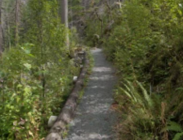
The section of trail with a slight drop off. Note the slightly loose gravel and grade.
The trail passes to the left of and slightly underneath a large boulder – you may need to duck a little if you are tall. Continue on a steady incline of 8-10% for approximately 50 feet, then the trail switchbacks right. There is a low bench on the left. Continue on a 3-5% incline.
At 0.2 mile you come to a fork. On the left, a footpath leads to a peaceful overlook of Newhalem Creek, detailed below. Go right on the gravel trail to the rock shelter. The trail continues generally level through old cedar and fir trees with burn scars, then comes to an 8% incline for about 10 feet. It levels out again and curves left with incredible views of the surrounding mountains.
At 0.3 mile you reach a wooden boardwalk above Newhalem Creek. A sign on the left reminds you that this is a protected site and entering the rock shelter is prohibited. There is a 0.5 inch rise onto the deck, which has level, even boards and is supported by rustic log poles. The boardwalk continues for about 100 feet and ends at a circular overlook. The rock shelter is on the left. Interpretive signs invite you to picture the scene from hundreds of years ago. The signs include quotes from Upper Skagit Tribal members and information about the spiritual significance of this area.

The viewing deck. Newhalem Creek cascades below.

The footpath to Newhalem Creek.
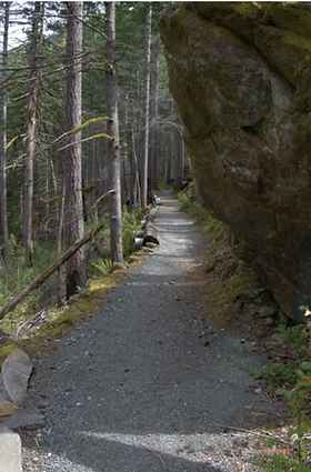
Where the trail passes a large boulder. Note the drop off and the grade.
“The Upper Skagit Tribe plays an integral role in preserving these sites which hold physical and spiritual connections to their ancient heritage. Many Upper Skagits continue their traditions as fishers, hunters and gatherers. They keep their culture alive through the teachings and counsel of Tribal Elders whose wisdom has passed to the spirits of the ancestors who walk this ground around you.” [quoted from an interpretive sign]. Enjoy the experience of this incredible place, but please be mindful.
To reach the contemplative spot along Newhalem Creek falls, backtrack and go right on the footpath that was mentioned previously. The trail is about two feet wide and natural surface with a few small rocks and roots. You are surrounded by new growth and burn-scarred trees. Rise and fall on 5% grades a few times, then curve sharply right as you approach the creek. The trail descends and curves left, then continues to descend on 10-20% grades for about 20 feet. It levels out and gets a little rocky, then rolls a few times as you reach the cliff above the creek with incredible views of a waterfall. You can pick your way along a rough trail, but it is rocky and steep in sections, and there’s a sharp drop off. This is a great place to rest and contemplate this beautiful place for a while before turning around and heading back to the trailhead.
Finding the Trailhead
Pass/Entry Fee:
None
Getting There:
From the North Cascades National Park visitor center in Newhalem, drive through Newhalem Campground Loop C. Continue straight for about 0.3 mile on the gravel service road. Cross the bridge and then there’s a couple of pull outs on the left. The trail begins at a sign on the right.
Nearby Alternatives:
Coming Soon
Land
Acknowledgement:
This is the homeland of the Upper Skagit people, who still maintain a life of sustenance and relationship with this land. This area was once called Duwaylib, which means goat snare. This site, rich in healing spirit, is offered by the Upper Skagit people and the National Park Service as a place for your visit and your trust. (from interpretive signage along the trail)