
Deschutes Falls
The Rundown
Spoon Rating:
4
Distance:
0.25 miles
Elevation Change:
varies
Typical Surface:
Natural; past the first lookout it is steep, muddy, and unevel
Typical Width:
4 ft
Nearest Town:
Olympia, WA.
Cell Phone Reception:
None. You will lose signal a few miles before you reach the park.
Amenities:
There is a caretaker onsite full time.
Why go?
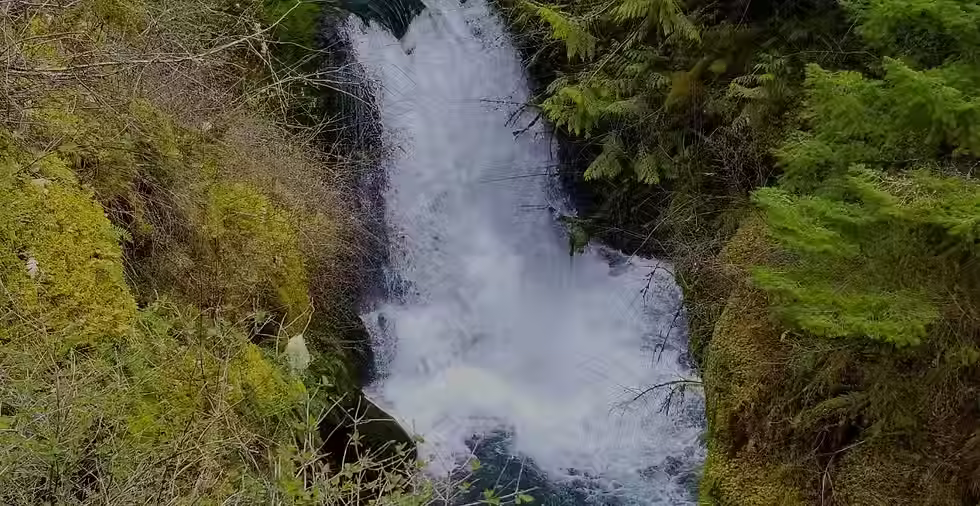
Deschutes Falls Park is a gem of the area with a long history for the indigenous people and local community. The 155-acre park re-opened to the public in September 2017 and offers up close, breathtaking views of the Deschutes River as it flows, cascades, and falls through the canyon created by the river’s powerful force. The tallest waterfall is 27 feet, plunging into a 70-foot gorge. There are many small waterfalls along the river with perfect viewing and sunbathing spots on the rocks. Dogs are allowed on-leash. Deschutes Falls Park is within the territories of the Puget Sound Salish and Yakama people.
The Hike
From the large gravel parking area, head down the wide gravel path. The first 50 feet of the descent is slightly steep, and then it becomes more level. There are a couple of benches along the way. The trail is accessible for a sturdy wheelchair, but the gravel is not compacted yet. You’ll start the .25 mile hike in a beautiful prairie and then move into the forest. Here you will come to a clearing with three forked paths and a bench. If you do not feel comfortable going further, this is a nice place to sit and listen to the river.
The right fork will take you to a steep, mulched then muddy path to the viewpoint below Deschutes Falls. This may be the easiest viewpoint of the big falls to access. There is four-foot fencing along the river and I used it to help me get down the path. There is less mud here than the other viewing area, and in the summer it may dry out. Still, when I visited following a relatively dry week, I had to step along the very edge of the fence and across some branches laid in mud that reached the top of my soles.
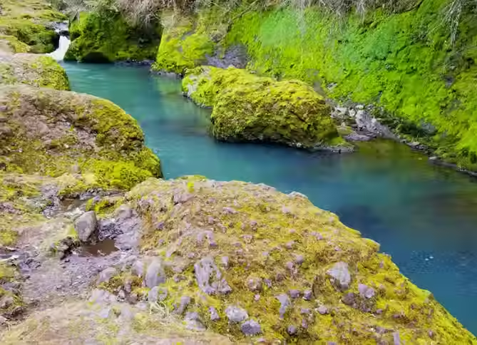
The rectangular photo captures the scene at an angle. Aqua blue water flows between a moss covered rock wall on one side and rounded rocks on the other. There is a small waterfall in the background.
The middle fork brings you to a viewpoint overlooking the top of the big falls, below a smaller fall that tumbles behind a tree reaching across the canyon. You will walk down a mulched path to a small, level bridge that crosses the creek that is the main source of so much mud.
The creek seems to be seasonal, but I am not convinced that it will dry up in the summer enough to allow all of the mud to dry out. Combined with the many feet that walk through here, I would anticipate the area to be muddy and slick throughout the year. Since the park is new, I am hoping the county will do some additional work to mitigate the problem and make it more accessible. You can safely check out the mud situation from the bridge to decide whether to go on.
To reach the main viewpoint, head to the right down a steep, muddy slope and across slick rocks where the creek flows through. At my visit, the mud at the viewpoint was as deep as the top of my soles, to over my feet in some places. I almost did not manage to make it down to the viewpoint even though I was feeling pretty good that day. Using my hiking poles, I managed to get sturdy enough footing. While the view was indeed stunning, I’m not sure I would risk it again without help.
The fork to the left from the clearing will take you to a level trail through the forest to additional viewing areas along the river. From this trail, the first path on the right will take you the other side of the middle viewpoint. The slightly steep mulched trail bypasses the bridge and the worst of the mud. It is an easier route down to the river and top of the cascading falls. There will be a short, steep footpath that you can take down to the river, but it is possible to get a partial view of the falls from here.
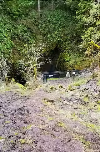
A muddy trail descends a slope to a fenced in viewpoint. The canyon wall is in the background, covered in green ferns and moss.

A muddy trail to an overlook with fencing.
Continuing along the main trail, you will pass through second growth forest of Western Redcedar and Douglas Fir and end up back at the river. To reach the viewpoints you have to walk down one of a couple of steep slopes. It was muddy when I visited but it looks like this area could dry out. Walk out onto the rocks that form the river gorge; they were dry and smooth but watch your footing because there is no fencing in this section. Here are some perfect spots to sit by the river and watch the beautiful aqua waters flow by, green moss and trees contrasting the rock of the canyon. There are some nice swimming holes if you are able to do that, but please be cautious as the falls are just a few hundred yards down river. In the summer the huge Big Leaf Maples will provide some shade, as will the towering cliff rising from the opposite side of the river. There is a lovely view of the surrounding hills.
The park basically ends here, so once you’re ready just head back the way you came.

A mulched path forks in a clearing beneath trees. There is a bench, and a caution sign that reads “safety is your responsibility. the natural terrain of this area can be dangerous. Obey all signs and remain in designated areas.

A moss lined canyon frames a cascading waterfall. An old tree stretches across the canyon, only the stump and roots remain.
Finding the Trailhead
Pass/Entry Fee:
N/A
Getting There:
Google Maps directions were surprisingly good; from Olympia, it is approximately one hour. Most of the trip will be on paved two lane county roads with some gentle curves. There are some incredible views of Tahoma/Mount Rainier. Once you get to Bald Hill Road, it is 15 miles to the park. A couple of miles before you reach the park you will enter timber land. The road will become narrower and curvier, and you will reach a fork with a sign that points you to the park and a dead end sign. This is a bit confusing – do not turn right, just keep heading straight towards the dead end. You’ll reach the parking area on the right in about a mile.
Nearby Alternatives:
I recommend stopping at the Monarch Sculpture Park near Tenino on this trip. Read my guide about the park here.
Land
Acknowledgement:
Deschutes Falls Park is within the territories of the Puget Sound Salish and Yakama people